So I have been slacking on the blog, but I am pretty sure that the reason for that is all the adventures I have been having this summer. I left off with my first two 14ers of the summer, Tyndall and Williamson. So I will pick up the story from there.
At the beginning of August I had a few days blocked off for a mountain trip and I was unsure of which mountains I should go climb. I had picked out a loop of 25 miles and 5 peaks, leaving out of the Onion Valley trailhead. However, I was also being drawn back to the Palisades region and the five 14,000' summits lying on the ridge around the Palisade Glacier. I went back and forth between these two options and eventually decided that heading to the Palisades as soon as possible would be my best bet for good snow conditions in the various couliors I would be using to attain the crest of the ridge line.
The Palisade ridge is rather long and complex, and in the area around the Palisade Glacier it creates a semi circular amphitheater rising above the snow and ice of the glacier. Along this arc of the ridge there are five summits that are included on the California 14er list, Mount Sill, Mount Polemonium, North Palisade, Starlight Peak and Thunderbolt Peak. By technical definitions only two of these are true "peaks", (Sill and North Pal), while the other three do not have enough prominence to classify as independent peaks. I am not sure why these three "non-peaks" make it on to the list of 14ers, but they are almost always included and they are all fun to climb.
My initial plan for the trip was to drive up, get my permit, and hike in to the glacier on day one. Day two climb Sill and Polemonium and day three climb Starlight and Thunderbolt then hike out and drive home. This plan evolved somewhat based on my energy and the conditions I found on the routes, and in the process became more awesome.
Once again my alarm went off early, and I lurched to the bathroom in an attempt to get out the door and on the road by 5am. I managed to arrive at the ranger station in Lone Pine shortly after the doors opened and in short order I had myself a permit for the North Fork of Big Pine Creek.
I reached the trailhead around 9:30 and took a few minutes to get myself and my gear in order. I did have a fair amount of gear since I knew I would be doing some snow climbing and I figured that camping at the glacier warranted bring my warmer sleeping bag. By 9:45 I was on my way.
I have taken to listening to audiobooks while doing long solo approaches in the mountains; it helps to pass the time while slogging up the more unattractive sections of trail. And at times it is a welcome distraction from thinking about pain and fatigue and how much damn trail is left before your destination. The first few miles of the hike up to the Palisade Glacier is one of those trails that can't be over fast enough for me. You slog uphill across the slopes of a valley that has no shade and steep enough sides to block out any sort of view. Fortunately, I was in good shape and had plenty of energy so I blasted through this section at a reasonably fast clip.
My fast pace fell of abruptly as I passed through a narrow stretch of the canyon and entered into the best Sierra wildflower bloom I have ever seen. I was still moving quickly, when I was moving, but I was stopping about every ten feet to take more pictures. There was a volume and variety of flowers along the trail that was literally jaw dropping. Tiger lilies, monkshood, paintbrush, delphinium and more. For an inveterate wildflower lover it was quite literally awesome.
Eventually I tore myself away, threaded through the trees and lakes, and continued up towards Sam Mack Meadow. Sam Mack is a beautiful grass-filled little valley, walled in by steep talus slopes on three sides. It would be a great place to camp, but I wanted to be as close to the base of my routes as I could manage. I crossed the little creek that flows through Sam Mack Meadow and headed up onto the slopes of the moraine. The trail across and up the moraine is somewhat loosely defined in sections, but relatively easy to follow, and by 3:15 I found myself at a lovely bivy cave on the north eastern edge of the glacier just below Mount Gayley.
Having accomplished my goals for the day, I sat down and ate some food. As I was eating Sill seemed so close and inviting and I had plenty of energy and daylight left so I figured that before it got dark, I could at least make it up to the top and back to within a distance from camp easily navigable by headlamp. So I packed up my ice axe and crampons and head out on to the glacier to climb Mount Sill.
The snow on the glacier was soft and heavily sun-cupped so the going was slow and some what tedious, still I did make pretty good time across the glacier and up on to the L shaped snow field. The L-shaped coulior is pretty low angle and despite the sloppy conditions I ascended to the bare rock at the top quite quickly.
I lucked out and once again I had fabulous conditions on top of a Sierra 14er just before sunset. Unfortunately, I forgot to bring my camera and I only have the few pictures that I took with my phone. I enjoyed a wonderful 30-40 minutes on top of Mt Sill in calm winds and warm sunshine.
My down climb was uneventful from a personal stand point, but I did witness a big rockfall off of Mount Gayley that dumped some large boulders onto the glacier across the route I had taken from my campsite to Mount Sill. On my way back to camp it was kind of spooky to cross the big fresh gouges the rocks left in the glacier. With out a stove to melt snow I had to make a bit of a field trip down to the lake at the toe of the glacier to fill up on water for the next day. The lake was only partially melted and the water tasted a bit silty, but it was the only option. I witnessed a spectacular sunset from the edge of the glacier and turned in for the night.
Somehow I slept in the next day and didn't get started on my day until 7am. I guess I had worn myself out pretty good the previous day. I packed up my climbing shoes, helmet, ice axe and crampons and headed out across the glacier towards the Underhill Coulior. My plan for the day was to climb the Right Underhill Coulior which meets the Palisade Ridge at a notch between Thunderbolt and Starlight peaks, then summit both peaks from there and descend the coulior back to the glacier.
Crossing the glacier proved to be substantially easier with the hard morning snow, and I made good time to the base of the Right Underhill Coulior. It looked intimidatingly steep all the way up until I was in the coulior itself. But in the end it was not so bad. I was able to kick steps in the snow in order to climb up to just below the chockstone that impedes progress at about the 2/3 mark of the coulior. I took off my crampons and awkwardly scrambled around the left side of the chockstone. The rest of the coulior had sparse and rotten snow in the bottom so I stuck to the rock on the side.
Soon I reached the top of the coulior, and was faced with the next step of my climb and the real meat of my day. From the notch I was faced with some wonderfully solid low angle rock up to the summit of Thunderbolt Peak. I chose to take the 5.6 variation straight up to the summit blocks and had a fun and easy time of it.
Once on the summit I was faced with the final challenge, the 5.9 summit block of Thunderbolt must be climbed to truly summit the peak, since the top of the block is the only part of the mountain that pokes above 14k feet. I spent a few minutes looking at the different sides of the block trying to figure out which would hold the easiest way up, and eventually I talked myself into putting on my shoes and climbing up the thing. It is relatively easy and short but I manged to terrify myself by nearly ripping off a tiny flake that I was attempting to use as a hold. All alone on top of a 14k foot peak is no time to fall 10 feet on to jumbled blocks of rock. I found instead that there was a great hold another foot to the left and once I committed to that I was on top in no time.
In theory, this was the most difficult part of my day from a technical standpoint, but there was plenty of fun climbing left to do and I had a decision to make. When I returned to the notch at the top of the coulior, there were two options ahead of me. I could stick with my original plan and summit Starlight Peak, retreat back to the coulior and descend it back to the glacier. Alternatively, I could summit Starlight, and then continue to traverse the ridge over North Palisade Peak, to Polemonium Peak, and then descend back to the glacier via the U-Notch. This second plan would avoid going back down the Underhill coulior and I was in favor of that. I had already been up and down the U-Notch and I found the idea of descending that coulior to be preferable. And on top of this, the traverse of the ridge all the way from Thunderbolt to Polemonium sounded like tons of fun.
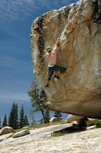
So I decided to go for it, I had plenty of time and energy and utterly, astoundingly fantastic weather. The traverse from the notch to Starlight was a bit confusing but I managed it without too much trouble and soon found myself staring somewhat apprehensively up at "The Milk Bottle." The summit block of Starlight Peak is a rather unique feature it is about 20' high and sticks up noticeably from the surrounding rock on the summit of Starlight. Like the summit block of Thunderbolt, the Milk Bottle must be climbed in order to truly summit Starlight Peak; it is very clearly the high point of the peak. Well, I once again put on my climbing shoes and despite some heavy breathing, I sat atop the Milk Bottle in short order. Many people have photos of themselves standing on top of the 2 sq ft summit of the block but I couldn't do it. In my defense, many of them are tied in to rope when they are up there, but I think I am just a wimp when it comes to standing on summits like that.
I gazed over at the top of North Palisade and tried to pick out the route I would take to get there. Once I decided on my path, it was fabulously easy and fun climbing and in no time at all I was sitting atop the Palisade Range. I hung out for a bit but soon I was pulled onwards to Polemonium and the completion of my mini Palisades traverse. Between the summit of North Pal and Polemonium lies the U-Notch and the last 200 feet of the descent to the U-Notch from North Pal is a steep chimney that has been rated anywhere from class 4 to 5.6 in difficulty. This is the section of climbing I was most nervous about soloing and as I approached it I was glad to have the ridge climbing of the previous few hours bolstering my confidence in my ability to be cool and safe while climbing solo. In fact I was so calm and even excited about the chimney that when I found it I didn't stop to put my climbing shoes on I just move into the chimney and flowed down the rock. It was a fantastic experience, I felt myself to be in total control and the downclimb was over before I knew it. I don't think I was even breathing hard. It was a very nearly transcendent moment.
Since I would be returning to the U-Notch for my descent to the glacier, I left most of my gear at the top of the notch before continuing up to Polemonium. The climb up was quick and sweet, yet more fun. The summit block was rather large and relatively flat, perfect for a little rest and relaxation in the perfect sunny weather that spoiled me rotten for all of my California 14er summits this summer.
After a few minutes I heard whoop of excitement from over on Mt Sill, so I whooped back, and tried to take a picture of the two figures I saw moving around on the summit. After a brief break on the summit I head back down to the U-Notch to begin my climb down to the glacier.
Descending the U-Notch was not fun. The top 1/3 of the coulior was solid ice under a very thin layer of snow, and this meant there was no kicking steps as I had done on previous snow coulior climbs. The method for ice is to kick the point of you crampons into the ice and stand on your toes like a climbing foot hold. I was very unnerved to be doing this, but after a few minutes of descending this way I realized I was only nervous because it was new. The actual climbing was quite easy and felt very secure. The descent took much longer than I had thought it would but soon the ice turned to snow and things sped up. I negotiated the bergschrund without too much trouble and found myself back on the glacier with all of the difficulties of the day behind me.
I headed back to camp, met and chatted with the father son team that had summitted Sill, and they invited me back to their family campsite at Third Lake where they promised there would be cold beer for me. I happily accepted and followed them down the trail once I had packed up. Fortunately for them I found their camera on the ground where they had stopped to fill up water and their good karma in offering me a beer was repaid by my return of their camera.
I spent an enjoyable evening with that lovely and interesting family and after watching the sun rise splashing light across Temple Crag the next morning, I bid them farewell and headed on down the trail to my car.
This trip led me to the top of four more 14k ft summits bringing my total to 11 of the 15 in California.
Wednesday, September 21, 2011
Subscribe to:
Posts (Atom)