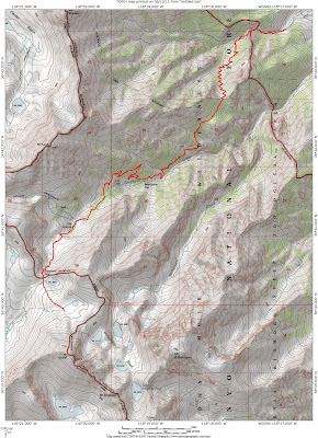
So, my mission to climb some mountains, and the decision to find inspiration by starting with California's 14ers, led me to target Mount Tyndall (14,018') and Mount Williamson (14,375). These two peaks lie within spitting distance of each other on the Sierra crest just west of Independence, CA and a few miles north of Mount Whitney. Neither of them are very technical, with the most difficult sections being very short and rated Class 3 at most. In fact, many reports list the hike in to the base of the mountains as the crux of the climb. The approach takes the Shepherd Pass trail for 10+ miles and reaches the Sierra Crest at Shepherd Pass (duh) which is just north of Williamson and Tyndall. The trailhead is at about 6200', so with a few ups and down on the trail and two 14ers to climb there is a lot of elevation gain involved in climbing these peaks.

My attempt on the mountains began in my bed in Sherman Oaks at 4:45am on a Monday. I had packed my backpack the night before and was ready to hit the road quickly. I tore my head off the pillow and dragged myself to the bathroom to get ready. Eventually, I was on the road making good time to Lone Pine to get wilderness permit at the ranger station. The ranger station opens at 8am and it takes about 3 hours for me to get there from my apartment. I got my permit quickly, right after 8 and hopped back int he car to see how close I could get to the trailhead. The road to the trailhead has about a two mile section that is listed as high clearance/ 4wheel drive and my honda civic is neither of those. I was expecting to have to park over a mile away and take the stock trail from an even lower elevation. However, I missed the parking for the stock trail and after about 5 mintues of driving along a relatively rough road (which was my no mean the worst I had been on in my car) I realized with some excitement that I was almost at the higher trailhead.

I started hiking right around 9:15am. The Shepherd Pass trail actually starts out heading up along Symmes Creek to avoid some big cliffs at the bottom of Shepherd Creek Canyon. After about a mile you switchback for a long time up and over a ridge that separates Shepherd Creek and Symmes Creek. Once you leave Symmes creek the terrain gets pretty dry and stays that way for a long time. A long stretch of sandy trail leads up above Shepherd Creek to Anvil Camp (10k ft), which is basically just a nice place to camp under some trees along the creek. It was at Anvil Camp that I managed to get myself off trail. For some reason, I was sure the trail stayed on the north side of the creek and as such I wandered off to the north looking for a trail that (in my head) continued from a turn off that I missed.

So I wandered off trail through some talus and meadows until I rejoined the trail at the Pothole (10,800'), another small camping area. Fortunately this wandering led me to some of the best wildflowers that I saw on the hike. Lots of my favorite, columbine, growing in the talus.


