The plan for this came about due to my continued drooling over the Sierra High Route which is a nebulous route put together by Steve Roper that travels roughly northward along the spine of the Sierra trying to stay in the magical zone above the treeline. The SHR incorporates a fair amount of cross country travel through areas that I had never even heard of before looking into the route. However, the route is not a loop there is a beginning and an end which is hundreds of miles away. So you can drive to one end, but then you need to figure out how to get back to your car at the start. If you have a partner or two you can take another car and leave it at the end, so that when you finish you just hop in and drive back to the start to pick up the other car.
Well I didn't have anybody to hike with me and I had lots of time so I decided to just walk back to my car, and since I would take the John Muir Trail most of the way back I figured I might as well complete the JMT and climb Mount Whitney. And from there it is just a few days back across the mountains and north to my car. I made my link from the SHR to the JMT at Tuolumne in Yosemite National Park. So in fact I cut both routes a bit shorter than the full length, but to try to link the two ends would have been very hard and might have required a car ride of some sort to make it not ridiculous. So I snipped of those end to tie it all together neatly. The whole loop comes out to something like 410 miles.

The red line is the High Route going North from Road's End in King's Canyon NP to Tuolumne in Yosemite NP. The blue line is the John Muir Trail heading South from Tuolumne to Mount Whitney. And the Yellow line is the route back to Road's end from Whitney over Colby Pass and Avalanche Pass.
On the hike I took a Thermarest Z-Lite sleeping pad, a Marmot Pounder 40 degree sleeping bag, an OR Aurora Bivy Sack, a Bearvault Bear Cannister, a headlamp, an Oricasa folding plastic bowl, a titanium folding spork, a 2L MSR Dromedary hydration pack, and a 1L Nalgene bottle. I had a few other odds and ends but that was the main gear list. And it all went in to a Lowe Alpine Cholaste 35L pack.
My food supply was fairly simple: Powdered milk and granola for breakfast, Nutella and tortillas for lunch and dried hummus and tortillas for dinner and cliff bars (Cool Mint Chocolate) to fill in between meals. I had a small supply of instant re-fried beans that substituted for the hummus on special occasions. On top of this, I had a little trail mix. But that is what I ate for 23 days or so. I started out with 10 days of food in my pack. I dropped off two resupply boxes at Red's Meadow near Mammoth. Red's Meadow is on the trail so I was able to resupply without heading in to town. I had one box with 6 days of food to last me up to Tuolumne and back to RM. And the other box had 10 days to get down to Whitney and then back to my car. (This is over 200 miles on 10 days of food, probably not good planning on my part, but it turned out not to be a problem due to several reasons that I will address as they come up.) Each box had an extra treat in it consisting of an 8oz Italian dry salami and an 8oz smoked cheese.
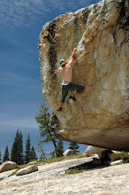
Before I left on the trip I went to do some alpine climbing with Dan Arnold. Basically this served to get me well acclimatized and ready for my hike. We also had a ton of fun traversing Rosy Finch Peak and climbing the North Arete of Bear Creek Spire and the North Buttress of Mount Goode.
 |
| From The Big Loop |
Mount Goode
On all of our climbs we encountered Sky Pilot a type of Polemonium that only grows above 12,000'
 |
| From The Big Loop |
Sky Pilot
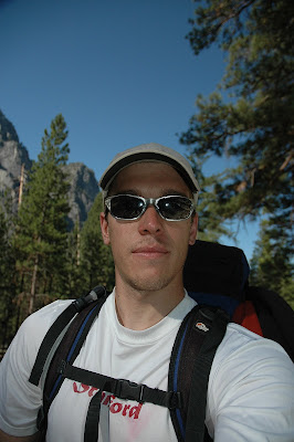
We had a great time climbing, and along the way I dropped off my food boxes in Mammoth. On August 4th, I dropped off Dan in Fresno and drove in to King's Canyon to pick up a wilderness permit for the hike. Due to a weird set of independently administered rules permits for trips beginning on the next day are available only after 1pm, but the permit office closes at 2:30. Strange, but I think I understand why that odd state of affairs exists. Eventually I obtained my permit and drove back to Fresno to complete my necessary purchases (batteries for my camera) and to eat my last meal before heading into the woods. After accomplishing that I drove part way back to the park and camped somewhere off the road.
On August 5th, I got up and drove into the park where I went to the Cedar Grove Restaurant and got a double order of biscuits and gravy for breakfast. From there I drove to the Copper Creek Trailhead at Road's End and packed up my gear. I put all the smelly stuff from my car into a bear box with a distant expected return date, and set out on the trail at 8:40am.
 |
| From The Big Loop |
To tell the rest of the story of my hike I will post in this space the exact notes I took from day to day along the trail. I scribbled them on the back of the maps I had printed out for the trip. These notes are by no means a comprehensive representation of my thoughts along the trail. I spent a lot of time on the trail by myself and there is no way I could capture all of my experiences in that respect. And on top of that most of them were written by a very tired guy just before he went to sleep and are a bit loopy and/or spotty in some cases. I will try to sprinkle in the appropriate photos in relevant places. (and as always, if you would like to see all of the photos I took you can click on any one of them and it will take you to the correct folder on my photo website.)
I will try to post a couple days of notes each day, starting tomorrow and continuing until I reach day 23. At which point I'll try to post something more to wrap up the trip my feeling from the trip and I guess that will be from about 3 weeks post trip and I might have some better perspective by then.
No comments:
Post a Comment